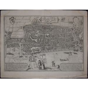
Prague and Egra, Antique Map from "Civitates Orbis Terrarum"
Braun G. & Hogenberg F. , Praga, Egra , from the collection Civitates Orbis Terrarum , Cologne, T. Graminaeus, 1572-1617. Image dimensions: 39.5 x 47.5 cm. Dimensions: 41 x 52.5 cm.
Wonderful B/W aquatint showing a great view of Prague and Egra . Good conditions, with a little hole and a medial usual fold on the paper sheet with two small rips on the upper and lower margins.
The Civitates Orbis Terrarum ( Atlas of Cities of the World ) was the second oldest printed atlas in the history of world cartography and the first atlas totally dedicated to topographical views . The first volume of this collection was published in Cologne in 1572; the following in 1575, 1581, 1588, and 1598. The sixth and final volume appeared in 1617, just before the extensive devastation wreaked by the Thirty Years’ War.


Validate your login
Sign In
Create New Account