Nordlingen, Antique Map from"Civitates Orbis Terrarum"
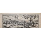
Braun G. and Hogenberg F. , Nordlingen from the collection " Civitates Orbis Terrarum ", Cologne, T. Graminaeus, 1572-1617. Image dimensions: 10.5 x 23.5 cm; dimensions: 10.5 x 26.3 cm.
Very fine B/W aquatint showing a v iew of the city of Nordlingen in lower Rhaetia . Very good conditions, with a lightly browned paper on the left.
The “ Civitates Orbis Terrarum ” ( Atlas of Cities of the World) was the second oldest printed atlas in the history of world cartography and the first atlas totally dedicated to topographical views . The first volume of this collection was published in Cologne in 1572; the following others in 1575, 1581, 1588, and 1598. The sixth and final volume appeared in 1617.
| SKU | J-71850 |
|---|---|
| Artista | Georg Braun, Franz Hogenberg |
| Typology | Original Prints |
| Technique | Aquatint, Etching |
| Editor | Cologne, T. Graminaeus |
| Periodo | 1600-1649 |
| Conditions | Good (minor cosmetic wear) |
| Dimensioni (cm) | 10.5 x 0.1 x 26.3 |
-
 Bear and Elf from "Intermezzi"Special Price 1.050,00 € Regular Price 1.400,00 €
 -
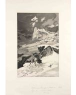
 Fallen RiderSpecial Price 900,00 € Regular Price 1.200,00 €
 -
 Love, Death and the BeyondSpecial Price 1.050,00 € Regular Price 1.400,00 €
 -
 Opus IV, Simplicius in der Waldeinode (Simplicius in the Wilderness)Special Price 900,00 € Regular Price 1.200,00 €
 -
 Opus IV Unter den Soldaten RadSpecial Price 900,00 € Regular Price 1.200,00 €
 -
 Simplicius at the Hermit's GraveSpecial Price 900,00 € Regular Price 1.200,00 €
 -
 Simplicius' Writing Lesson (Simplici Schreibstunde) (plate VII) from IntermezziSpecial Price 900,00 € Regular Price 1.200,00 €
 -
 Moonlit Night from IntermezziSpecial Price 900,00 € Regular Price 1.200,00 €
 -
 Pursued Centaur (Verfolgter Centaur)Special Price 900,00 € Regular Price 1.200,00 €
 -
 Seaside from IntermezziSpecial Price 900,00 € Regular Price 1.200,00 €
 -
 Kämpfende KentaurenSpecial Price 900,00 € Regular Price 1.200,00 €


-
 The Dance488,00 €
 -
 Scholars250,00 €
 -
 The Hen188,00 €
 -
 Rider480,00 €
 -
 Piazza San Pietro850,00 €
 -
 There is no More Religion640,00 €
 -
 Octopus2.250,00 €
 -
 Portrait of S. John400,00 €
 -
 Child Prodigy400,00 €


Validate your login
Accedi
Creare un nuovo account