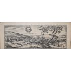
Bruges, Antique Map from "Civitates Orbis Terrarum"
Braun G., Hogenberg F., " Bruges ", from the collection " Civitates Orbis Terrarum" , Cologne, T. Graminaeus, 1572-1617. Image Dim: cm 32 x 46.5 , Dim: cm 40.5 x 52.5 .
Hand-colored aquatint representing a map of the City of Bruges, capital of Flanders. Very good conditions , with a little medial fold, some stains and a browned paper.

Braun G., Hogenberg F., " Bruges ", from the collection " Civitates Orbis Terrarum" , Cologne, T. Graminaeus, 1572-1617. Image Dim: cm 32 x 46.5 , Dim: cm 40.5 x 52.5 .
Hand-colored aquatint representing a map of the City of Bruges, capital of West Flanders . Very good conditions , with a little medial fold, some stains and a browned paper.
From the “Civitates Orbis Terrarum” ( Atlas of Cities of the World), the second oldest printed atlas in the history of world cartography and the first atlas totally dedicated to topographical views . The first volume of this collection was published in Cologne in 1572; the others following in 1575, 1581, 1588 and 1598. The sixth and final volume appeared in 1617, just before the extensive devastation wreaked by the Thirty Years’War.
“ The most original and magnificent of all city-atlases, which drew on the work of accomplished topographical artists; and…reproduced it in pictorial compositions of great charm and individuality”. R.A.Skelton
| SKU | J-71873 |
|---|---|
| Artista | Georg Braun, Franz Hogenberg |
| Typology | Original Prints |
| Technique | Aquatint, Etching |
| Editor | Colone, T. Graminaeus |
| Periodo | 1550-1599 |
| Conditions | Good (minor cosmetic wear) |
| Dimensioni (cm) | 40.5 x 0.1 x 52.5 |


-
 Trace800,00 €
 -
 Miriam and the Prophetess300,00 €
 -
 Rome-Celebrations in Piazza Venezia350,00 €
 -
 Silhouette350,00 €
 -
 Blue Tit200,00 €
 -
 The Temptation1.400,00 €
 -
 Escape 2420,00 €
 -
 Sword Fight500,00 €
 -
 Ex Libris Hejna206,00 €
 -
 Eurydice380,00 €


Validate your login
Accedi
Creare un nuovo account